
Beholder of All Ages:
The History
of the World in a French Mappemonde
- Stephen Boyd Davis
_______________________________
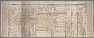
Fig. 1. J. L. Barbeau de la Bruyère, Mappemonde
historique…, 1750 
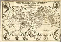
Fig. 2. N. de Fer, Mappe-monde…, 1717
A chart published in 1750 by Jean-Louis Barbeau de la Bruyère (1710-1781) attempted to map historic time against location (fig. 1). The author’s Explication, published some time after 1760, offers this startling remark:
Seroit-ce trop dire, que Dieu qui s’appelle dans les Ecritures, Conspector Seculorum, & qui a créé l’Homme à sa ressemblance, le met en état par ce Plan, & autres semblables, de voir d’un coup-d’il tous les Siécles passés, comme présens devant lui ?
Would it be too much to suggest, that God who is called in Scripture, the Beholder of all Ages, and who has created Man in His image, enables Man by this Plan, and others like it, to see, at one glance, all the Centuries that have passed, as though present before him [1]?
We sense the ambition — and the hubris — of a chart that claims to offer to humankind the same view of all history that hitherto only God has enjoyed, epitomising Enlightenment aspirations for human knowledge. The chart in question was named a mappemonde — the Mappe-monde historique ou carte chronologique, géographique et généalogique des états et empires du monde — a title that emphasises the totalising aims of the project. A mappemonde in that period was a pair of circular maps presented together to show the whole world as two hemispheres (fig. 2), but this chart maps the world and time differently, as will become apparent. The word mappemonde was also used metaphorically in this period by d’Alembert in the Discours Préliminaire to describe the knowledge structure of the Encyclopédie [2]. He used it to emphasise that publication’s systematic organisation and completeness. Completeness was a watchword for many authors and publishers at that time, though Barbeau is caustic about publications that claim to be complete world histories when they omit newly discovered peoples and even great empires [3]. Later in the century, the word mappemonde would be extended facetiously to a face covered in lines or scars [4] and even to the eroticised body [5], but in the 1750s the predominant use of the term was in a strictly cartographic sense.
Barbeau’s ambition was to map all of the known world combined with all of time since the Flood. In his commentary Idée et Usage de cette Carte, printed in the side panels of the chart itself, he sets out a plan to show: ‘tous les Royaumes, Empires, Républiques & grands Peuples qui ont figuré sur la Terre depuis la Dispersion des Hommes après le Déluge jusqu’à présent’ (all the Kingdoms, Empires, Republics and great Peoples which have appeared upon the Earth since the Scattering of Man following the Deluge down to the present time [6]). All this was to be achieved within a single view. His opening words are, ‘On voit ici du premier coup d’il...’ (Here are seen at first glance) and he goes on to claim that the dynamic processes associated with nations — their birth, growth, their different circumstances, duration, dismemberment and end — are ‘réduits, avec ordre & précision, en un seul corps; de manière que c’est ici comme le Tableau Politique de l’Univers’ (concentrated, with order and precision, into a single entity; in such a way that we have here a Political Portrait of the whole World [7]). Barbeau’s assertion, that vast extents of territory and periods of time can be made visible under a single all-encompassing view, becomes an increasingly common claim for chronographic visualisations, suggesting that the eye can effect rapidly what the intellect can only achieve with difficulty [8].
Prior traditions in depicting historic time
Rosenberg and Grafton [9] offer an indispensable survey of ‘cartographies of time,’ presenting timewise visualisations created over several centuries down to the present day. While eighteenth-century chronographics in general, and Barbeau’s in particular, demonstrate a strong cartographic impulse [10], two prior traditions emerge strongly in Rosenberg and Grafton’s study: the typographic and the pictorial.
The typographic tradition developed from the list. Lists, rather than natural language, dominate the corpus of early writing. Important among these are annals, event-lists and king-lists [11]. In a simple list, events are named, and maybe dated, in sequential order, and are organised on the page as a row or column. A list tells us about order only: a significant advance in representational capacity is the table or matrix. This makes it possible to coordinate multiple lists in time, showing not only sequence but synchrony. A landmark is Eusebius’s Chronicle of c300CE, which synchronised Christian history with that of the Pagans and Jews in a series of parallel columns [12]. There may have been earlier examples. Feeney speculates that such a parallel listing, synchronising Athenian archons with Roman consuls, might have occasioned Cicero’s enthusiastic ‘explicatis ordinibus temporum uno in conspectu omnia uiderem’ (with the ranks of times deployed, with one overview I could see everything [13]). Such matrices still fail to offer two important pieces of information: the intervals between events and an overall sense of scale. Some attempts were made to create tables that would overcome this problem. Helvicus not only argued for tabular alignments of events to bring out the ‘Synchronism of Famous Men, renowned either for their Vertues or their Villanies’ [14] but also organized his tables so that equal durations occupied equal amounts of paper, introducing blank rows in his table in order to achieve this: Præcipuum, quod in hoc Systemate spectavi, est annorum a Mundo condito ad nostra Tempora usque per æqualia Centenariorum et Decadum spacia distributio, ob eximium usum, qui inde resultat (The main goal I aimed at in this treatment is an equal distribution of years between the Creation and our time in intervals of 100 and 10 years, because it is so useful [15]). Every double-page spread of his first folio edition represents 100 years, making it easy for the reader to estimate intervals between dates. The argument about whether equal time ought to occupy equal space would continue indefinitely. Blair in the preface to his Chronology and History of the World [16] singled out the uniform timescale in Helvicus’ tables for praise ‘because they give a more united View of the Collateral Succession of different Kingdoms.’ Blair’s instructions to the bookbinder also make clear the importance to him of synchronism: ‘...be careful to make the black Lines in one Plate stand exactly opposite to the black lines on the Plate which corresponds to it, that each may appear as if it was one continued Line, otherwise the whole Use of the Tables will be lost [17].’ On the other side of the argument, the introduction to an English edition of Lenglet du Fresnoy’s Chronological Tables of Universal History complained at Blair’s style of tabular chronology, which ‘must always have this inconvenience, that the same, or nearly the same space upon paper being allotted to one year as to another, some barren years will have blank columns, and some years crouded with events, cannot be fully dilated and displayed [18].’ The tension between the desire for what we might now call ‘big data’ and the limitations of printed paper or other physical substrates explains many of the hard choices that the authors and publishers of chronologies had to grapple with until the advent of digital media. It will become clear that Barbeau’s Mappe-monde used a distinctive approach to the question of temporal scale.
[1] J. L. Barbeau de la Bruyère, Explication Générale de la Mappemonde Historique, Paris, Hérissant, [1750]), p. 38.
This is catalogued at Dijon as ‘[1750]’ but contains an internal reference to a 1760 publication. Copy in the Bibliothèque Municipale Dijon: Fonds Ancien 12990 CGA.
The phrase Conspector Seculorum is taken from Ecclesiasticus, one of the seven Deutero-Canonical books found principally in Catholic Bibles.
The context in the Latin Vulgate is:
18. … et exaudi orationes servorum tuorum
19. Secundum benedictionem Aaron de populo tuo: et dirige nos in viam justitiae, et sciant omnes qui habitant terram quia tu es Deus conspector saeculorum.
The Challoner revision of the Douai-Rheims Bible (1750) translates this in English as:
18. … and hear the prayers of thy servants,
19. According to the blessing of Aaron over thy people, and direct us into the way of justice, and let all know that dwell upon the earth, that thou art God the beholder of all ages.
[2] J. le R. D’Alembert, ‘Discours Préliminaire’, in Encyclopédie ou Dictionnaire raisonné des sciences, des arts et des metiers, 28 vols, Paris, Braisson, David, Le Breton, Laurent and Durand, 1751, vol. 1, pp. i–xlv, p. xv. Available on the site of the ARTFL Encyclopédie Project (Accessed 9 May 2015).
[3] J. L. Barbeau de la Bruyère, Explication Générale de la Mappemonde Historique, Op. cit., p. 36.
[4] F. de Quevedo, Oeuvres choisies de don François de Quevedo, Traduites de l’espagnol, [La Haye], 1776. Available on Gallica (Accessed 9 May 2015), p. 150.
[5] A.-R. A. de Nerciat, Les Aphrodites ou Fragments thali-priapiques pour servir à l’histoire du plaisir. Place of publication claimed as ‘Lampsaque’ (the alleged birthplace of Priapus) on title page. 1793. Various references. Available on Gallica (Accessed 9 May 2015).
[6] J. L. Barbeau de la Bruyère, Mappe-Monde Historique, ou Carte Chronologique, geographique et généalogique des États et Empires du Monde, Paris, 1750. British Library Maps K.Top.4.46.2. Explanatory rubric on the chart.
[7] J. L. Barbeau de la Bruyère, Mappe-Monde Historique, Op. cit. Explanatory rubric on the chart.
[8] S. Boyd Davis, ‘May not duration be represented as distinctly as space? – geography and the visualisation of time in the early eighteenth century’, in David Beck (ed.) Knowing Nature in Early Modern Europe, London, Pickering and Chatto (in press), pp. 119-137, p. 127.
[9] D. Rosenberg and A. T. Grafton, Cartographies of Time: a History of the Timeline, New York, Princeton Architectural Press, 2010 passim.
[10] S. Boyd Davis, ‘May not duration be represented as distinctly as space? – geography and the visualisation of time in the early eighteenth century,’ Op. cit. passim.
[11] J. Goody, The Domestication of the Savage Mind, Cambridge University Press, Cambridge, 1977, p. 80.
[12] D. Feeney, Caesar’s Calendar: Ancient Time and the Beginnings of History, Berkeley, CA, University of California Press, 2007, p. 29.
[13] D. Feeney, Caesar’s Calendar…, Op. cit., p. 28.
[14] C. Helvicus [Helwig], The Historical and Chronological Theatre, London, 1687, n.p.
[15] C. Helvicus [Helwig], Theatrum Historicum, Giessæ Hessorum [Gießen], Hampel, 1609, n.p. British Library General Reference Collection, 747.c.22.(1).
[16] J. Blair, The Chronology and History of the World, from the Creation to the year of Christ, 1753, illustrated in LVI tables, London, 1754. From the Preface, n.p.
[17] Ibid. From the Preface, [7].
[18] T. Flloyd, Preface to an English edition of: N. Lenglet Dufresnoy, Chronological Tables of universal history, sacred and profane, ecclesiastical and civil; from the creation of the world, to the year one thousand seven hundred and forty-three, 2 vols, ‘Translated from the last French edition, and continued down to the death of King George II.’ Vol.1, London, 1762, p. vii.


